Originally appeared on Nodalities Blog: http://blogs.talis.com/nodalities
 Last week, I met up with some folks who are building some amazing things with public data. After seeing their Postcode Paper project, I was left with the lasting impression that given the raw materials, there is very little hindrance to what can be built.
In the Postcode Paper, Tom Taylor, Gavin Bell, and Dan Catt brought together data from a whole bunch of online sources into a single resource which can be easily distributed to residents of a local neighbourhood. Also, because this proof-of-concept is a real newspaper (i.e. made from paper and everything), it bridges any digital divide and gives access to people who might not otherwise find such information online.
To me, the real brilliance behind the paper is the context it provides for your location. Through its simple newspaper metaphor of headings and sections, one can very quickly find something exactly, or absorb trivia by browsing the headings. So, for example, there is a section for “Healthcare” which provides a list of dentists, GPs, A&E services and the name of the Primary Care Trusts serving your area. Combining this kind of immediately useful information with some general facts about an area (crime rates and trends, green-space, recycling centres and even allotment information) gives a profoundly well-informed picture of a given neighbourhood.
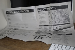
In a stroke of genius, the lads have added travel times from that postcode to a series of important destinations along with travel times. So, from E5 0JA to Oxford Circus takes 4 minutes via bicycle and 42 on public transport; and it’s 3 hours to Paris or Bristol on the train.There’s even a route-map for local busses and Underground transport.
Part of the thinking behind it is that local authorities could print these every few months or so to send to newcomers. Imagine finding such a rich resource in your post after paying council tax for the first time! I’ve lived in my current town for 2 years now, and I don’t know about half the information this contains. It’s presented extremely clearly and in a very familiar format, so there is very little problem communicating across generational, cultural or potentially even linguistic divides. (Much of the information, such as journey times, doctors surgeries and crime rates would need little translation.) It also doesn’t take much imagination to see additional features or benefits spinning off of this kind of service.
Put the paper online, with live-updates of the information and widgets for transport. Add in some basic demographics (gender, age bracket, long-time resident or visitor), and you’ve got hugely-flexible possibilities for providing an extremely clear UI to your community’s site. Tailoring some specifics, such as age, might let you see more information about local schools, for example, then about old-age care. With print-on-demand kiosks in local libraries and post-offices, you could have an up-to-date snapshot of your neighbourhood whenever you need. This could be used by school children for local projects (and if they can tailor the paper themselves, how much more exciting!). It could be an aid to public transparency with clearly-presented statistics like crime and school standards rates. The list of ideas is endless, really.
That’s the vision, any way. In reality, there are still some huge hurdles to cross before this kind of service could even begin to become a reality. This project took only a few days to put together, but the supremely brainy folk behind it have years of data management skills behind them. They focused on a single postcode, and many of the data needed had to be hand-scraped from various sites and files. The work needed to launch an on-demand service would be daunting indeed, because no local authority would provide a unified point of access for this kind of information. Currently, if a council wanted to provide this kind of resource, researchers would have to go out and find the facts and figures from across the web (NHS sites, central and local government sites, education and reporting services, etc), compile them and produce an individual layout for each individual postcode. And, if you’re an organisation interested in this, you would potentially be required to pay £1000s to access the basic building-blocks: post code lookups and survey boundary data. Needless to say, local authorities and businesses would be hard-pressed to find the time to build such papers to such a fine level of localisation.
Any startup, application, or service wanting to offer localised information is up against some severe inclines. It takes little imagination to see this paper and similar applications taking off and providing huge benefit to where people spend most of their time—at home. However, I fear much of these innovations will remain in imaginations as long as so much of the material needed to build them remains locked away.